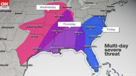
The storms will barrel toward the East Coast through Friday, unleashing tornadoes, damaging winds and hail along the way, from the Texas Panhandle to the coast of the Carolinas.
Over three days, the storm will affect more than 100 million people and traverse about 1,400 miles, including parts of the Southeast and Mid-Atlantic that got battered over the weekend by severe weather.
As the system treks east, parts of the Southeast could experience severe weather Thursday, with a large swath of the East Coast on track to feel impacts on Friday.
"The greatest threat will be damaging winds and very large hail, but tornadoes will also be possible," the National Weather Service said.
A massive storm system killed eight people in the South over the weekend and caused damage from Texas to Mississippi. Four people died in Texas, two in Louisiana, one in Mississippi and another in Alabama.
Wednesday: From Texas to Kansas
Storms will begin Wednesday in the middle of the country, with the most significant threat stretching from central-southeastern Texas to southern Kansas.
Strong winds are possible, along with the risk of a few tornadoes. The biggest concern is the potential for large hail, possibly 2 inches or more in diameter, for places including Dallas and Austin, Texas, and Wichita, Kansas.
Those areas face an "enhanced risk" of severe thunderstorms -- the third of five risk levels -- according to the National Weather Service's Storm Prediction Center.
The storms, expected to organize Wednesday afternoon across the southern Plains, will become more widespread in the evening and into the night.
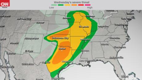
Beyond the "enhanced risk" zone, a "slight risk" (Level 2 of 5) of severe storms extends from the Mexico-Texas border to southern Wisconsin. That includes densely populated areas around San Antonio, Oklahoma City, and St. Louis, Missouri.
Thursday: From Louisiana to Tennessee
As the system pushes east, the tornadoes risk increases, as the environment becomes more conducive to tornadic storms.
Louisiana and Mississippi will be at risk Thursday morning, with the storms moving into Alabama on Thursday evening through the overnight hours. The Deep South also faces an "enhanced risk" (Level 3 of 5) of severe storms, the Storm Prediction Center said.
Some cities facing that level of risk include Baton Rouge and New Orleans, Louisiana, and Mobile and Birmingham, Alabama. A "slight risk" (Level 2 of 5) has been declared in Memphis and Nashville, Tennessee.
Damaging winds, hail and strong winds will continue to be a concern during this second day of severe weather.
Friday: From Florida to Washington
By early Friday morning, the system will move through Georgia and near the coastal Atlantic states by afternoon. The severe storm threat ramps up through the day from the southern tip of Florida to Washington DC.
The coastal Carolinas and southeastern Virginia have the greatest potential for severe weather. That zone has been declared at "enhanced risk" (Level 3 of 5) by the Storm Prediction Center.
Overall conditions within the broad system should allow for a few individual storms to intensify. Damaging winds and tornadoes will be possible, especially within the "enhanced risk" area.
The threat should diminish throughout the overnight hours as the cold front associated with the potent storms finally pushes off shore.
Bagikan Berita Ini


0 Response to "Another blast of severe storms aims for places still recovering from tornadoes"
Post a Comment