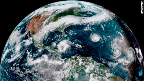
Florence was about 685 miles southeast of Bermuda as of 11 p.m. ET on Sunday. The storm had maximum sustained winds of 90 mph and was moving west at about 7 mph, the National Hurricane Center (NHC) said.
"Florence is forecast to rapidly strengthen to a major hurricane by Monday night, and is expected to remain an extremely dangerous major hurricane through Thursday," the National Hurricane Center said.
Large swells generated by Florence are already affecting Bermuda and portions of the East Coast and will continue this week, the hurricane center said.
"These swells are likely to cause life-threatening surf and rip currents," the National Hurricane Center said.
The center of the hurricane was forecast to move between Bermuda and the Bahamas on Tuesday and Wednesday and approach the southeastern coast of the US on Thursday as a Category 3 storm or higher.
"There is an increasing risk of two life-threatening impacts from Florence: storm surge at the coast and freshwater flooding from a prolonged heavy rainfall event inland. While it is too soon to determine the exact timing, location, and magnitude of these impacts, interests at the coast and inland from South Carolina into the mid-Atlantic region should closely monitor the progress of Florence, ensure they have their hurricane plan in place, and follow any advice given by local officials," the National Hurricane Center said.
East Coast track
CNN senior meteorologist Dave Hennen said Sunday that computer models agree Florence is on track to make landfall in the Carolinas.
It would be the first Category 3 or higher storm to hit the East Coast since Jeanne struck Florida in 2004.
To become a hurricane, a storm must reach sustained winds of 74 mph.
Most computer models predict Florence will slow down as it moves inland, Hennen said, which could add to the heavy rains and potential flooding.
Virginia, North Carolina and South Carolina already are on alert. Their governors declared states of emergency Friday and Saturday.
"We are preparing for the worst, and of course hoping for the best," South Carolina Gov. Henry McMaster said, adding that his declaration would allow state agencies to deploy assets quickly to the coast.
McMaster said Sunday that he has asked President Trump for a federal disaster declaration. That would make state and local agencies eligible for FEMA reimbursement of some costs.
North Carolina Gov. Roy Cooper waived certain transportation restrictions so that farmers could harvest and move crops more quickly.
Cooper also urged people to learn what evacuation routes to take, and put fuel in their vehicles in case they're ordered to leave.
"Action today can avoid losses due to Florence," he said.
Ships out to sea
The US Navy said Saturday that it may be necessary to send ships in the Norfolk, Virginia, area out to sea because of the coming storm. The Navy put them on Sortie Condition Bravo, which means the onset of destructive weather is within 48 hours.
In a news release, the Navy said the ships can handle destructive weather better while at sea and that "having the ships underway also makes them ready and available to respond to any national tasking, including any needed disaster response efforts in the local area after the storm has passed."
Peak season
Preparations for Hurricane Florence come as the Atlantic hurricane hits its peak. Two other storms also are churning in the Atlantic.
Hurricane Helene and Hurricane Isaac are not expected to hit the US mainland.
A combination of factors make September 10 the statistical peak date of hurricane season, CNN meteorologist Pedram Javaheri said.
The Atlantic hurricane season officially begins June 1, but cooler water and higher wind shear -- winds moving at different speeds and directions -- early in the season are less than ideal for tropical systems to gain and maintain strength.
Storms increase in frequency and intensity by mid-August and into September as temperatures in the Atlantic climb to their highest levels, Javaheri said.
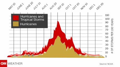
"Take mid-August to mid-October, that period accounts for 87% of category 1 and 2 hurricane days and a staggering 96% of 'major' hurricane days -- (Categories 3, 4 and 5)," he said. "By late October, wind shear once again increases and the cooler autumn air filters farther south, allowing waters to begin their inevitable cooling process."
CNN meteorologist Gene Norman compared the conditions to boiling water on a stove, with the water taking a while to react to an increase and then decrease in the temperature of the element beneath it.
"Even though the season starts in June, the Earth is just beginning to warm up from the summer sun. By mid/late August, temperatures near their peak, like that pot on the stove starting to boil," he said. "However, just as it takes a while to heat the ocean, it also takes a while for the latent heat stored there to dissipate, like that pot on the stove. This is why there can be strong storms lingering into October."
Bagikan Berita Ini


0 Response to "Florence set to mark peak of hurricane season as major storm"
Post a Comment